‘Winds that sound like banshees’: residents told to take shelter as Pilbara braces for Tropical Cyclone Mitchell
Severe Tropical Cyclone Mitchell is expected to maintain its category 3 intensity as it barrels along the Pilbara coast before making landfall.
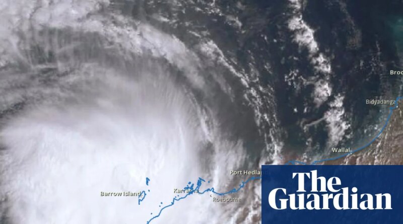
Located west of Karratha, the cyclone was about 30km offshore with 120km/h winds near the centre and gusts up to 165km/h on Sunday morning, according to the Bureau of Meteorology’s latest track map.
“The expectation is that it will maintain its category 3 intensity as it moves south-west today, parallel to the Pilbara coast,” said senior meteorologist Miriam Bradbury. Although the cyclone could intensify or even slow down slightly as it continues south-west over water.
The cyclone was expected to make landfall between Exmouth and Onslow late on Sunday evening or early Monday morning.
Sign up: AU Breaking News email
A warning zone stretching from Karratha to Cape Cuvier, just north of Carnarvon, has been declared. Those areas were the most likely to see gale force or damaging winds, although very destructive wind gusts of up to 170km/h could develop as Mitchell’s core approaches the coast.
EmergencyWA has issued cyclone emergency warnings stretching from Dampier to Onslow, urging residents to shelter indoors immediately.
Exmouth shire president Matthew Niikkula said the town had not experienced a cyclone of this strength in a decade, and conditions could be “extremely frightening”, with “winds that sound like banshees running around outside”.
Infrastructure damage was a particular concern, with authorities working to keep water and power running and roads clear.
“Being on a peninsula, there’s one road in and one road out and it’s very susceptible to flooding,” Niikkula said.
Evacuation centres were open at the Karratha Leisureplex, Onslow multipurpose centre and the Exmouth shire hall.
Wind gusts of 169km/h were recorded at Legendre Island at 7pm Saturday, and 148km/h at Barrow Island on Sunday morning.
“It’s mostly the islands that are being caught at the moment, but we’ve still had 90–100km/h wind gusts on that coastal fringe too at places like Port Hedland and Karratha,” Bradbury said.
Widespread moderate to heavy rain, with the possibility of flash flooding was expected over the west Pilbara coast, along with abnormally high tides. Those hazards would extend to the Gascoyne region on Monday.
Karratha had recorded more than 70mm of rain since midnight.
“The rain comes in, our rivers start rising, and we’re likely to see impacts for roads, access routes, impacts for communities through those areas too,” Bradbury said.
All ports in the Pilbara had been closed.
Many guests staying at the Karratha Econo Lodge hadn’t experienced a cyclone before. Venue manager Nadine Askevold said some were “a bit nervous”, adding that staff had supplied guests with information and cyclone packs, including torches and water.
Moisture streaming from the tropics, including from Tropical Cyclone Mitchell, was contributing to the risk of severe thunderstorms across central and south-eastern states, including parts of New South Wales, Victoria, Tasmania and inland South Australia.
Bradbury said that was significant, because storms could bring rain to some very dry parts of the country.
On average, Australia experienced about 10 tropical cyclones each seasonwith 3 to 4 making landfall. This season, Mitchell has followed tropical cyclones Fina, Hayley, Koji and Luana in crossing the coast.
Fewer tropical cyclones were anticipated with a warming climate, but the proportion of severe events could increase, according to the national climate risk assessment.
– with AAP